

Maps for MicroStrategy
Effortless & sophisticated mapping for your business.

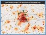
Insightful
Visualize your data to create heatmap, hotspot, cluster and voronoi diagrams with just a few clicks.
Analytical
Analyze your data as a map without time-consuming, expensive mapping tools.
Intuitive
Create presentation-quality maps of your data using our automated configuration tools.
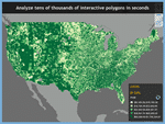
Scalable
Visualize hundreds of thousands of entities & full postal code polygon maps in seconds.
Key Features
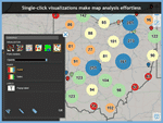
One-Touch Formatting and Visualizations
See your data in many interactive visualizations simply by selecting heatmaps, hotspots, pie charts, Voronoi partitions, point clusters or dozens of point styles.
Macro-based Label Editor
Create rich text labels with embedded values and attribute data. Popups and Embedded labels allow for easy analysis of any map entity.
Printing
Print your map directly from within MicroStrategy in the same way that you are accustomed to printing today.
Value-based Thematic Sequences
Automatically or Manually distribute your data to be optimally viewed and analyzed. Page by all of your values to quickly change the map view.
Multi-layer Maps
Layer multiple geographic columns onto a single map view. Layer your stores and customers on top of Postal Codes, States, Counties, Countries and more.
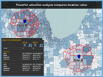
Advanced Selections
Select, analyze, aggregate and compare areas of your geographic data with polygon, distance radius, and line buffer tools.
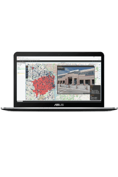
Powerful, interactive maps
Visual Crossing’s new version 4 platform is available for MicroStrategy Web, Mobile and Desktop. It was designed both for simple mapping tasks as well as highly scalable and sophisticated multi-layer mapping. It is the only complete, easy-to-use mapping solution available for MicroStrategy.
With powerful, interactive maps you can achieve new insight from your existing dashboards and reports all from within the MicroStrategy interface that you already know. Quickly create presentation quality maps and analyze large geospatial datasets using our proven analytics and advanced visualizations.